Volcanoes: forecasting and tourism
Research and impact 11 December 2019
The tragedy of the eruption of Whakaari, or White Island, volcano in New Zealand made me keen to question a volcanologist here at the Department of Earth and Environmental Sciences, University of Manchester, to find out more about forecasting and tourism. I spoke to PhD student Ben Esse to try and understand why eruptions happen and how tourism functions in relation to the risks.

When I brought up the White Island eruption to Ben, the first thing he mentioned to me was the need to know who to go to for expert information, naming GeoNet and the New Zealand National Emergency Management Agency (U.S. Geological Survey and the Global Volcanism Program are good for general volcanology as well) as the main sources that anyone concerned or interested should refer to. He also pointed out that, while volcanoes can be breath-taking examples of the power of the natural world, there is always a risk when visiting an active volcano – they have the capability to produce violent and destructive events.
“Every volcano is different.”
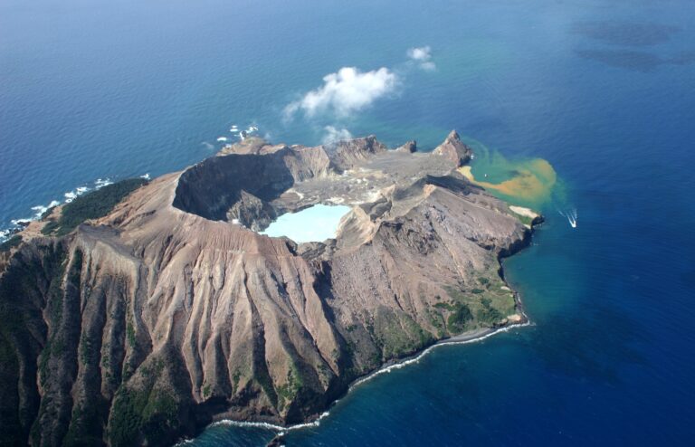
As news coverage has widely reported, the White Island (or Whakaari) volcano is New Zealand’s most active volcano. Ben thought that the eruption could have been a phreatic eruption, where magma comes into contact with water and this is then flashed explosively into steam. I asked if this could have been forecasted, and Ben noted that phreatic eruptions don’t tend to have as clear precursory signals as, for example, magmatic eruptions, and so can be harder to forecast. Phreatic eruptions can happen rapidly and without much warning. I asked if the type of volcanic eruption correlates to tectonic plates. Ben stated that the location of a volcano can influence the style of eruptions through the consistency of the magma: volcanoes on destructive plate boundaries (such as those found around the Ring of Fire) tend to have more viscous lava which produces volcanic eruptions that are violent and explosive. Volcanoes with a more runny lava, such as those on constructive plate boundaries or mantle plumes (such as Hawaii) tend to produce less explosive eruptions with lava flows.
Ben emphasised that the type of eruption that took place on White Island is unconfirmed at this stage, and I wondered how forecasting works. Ben pointed out a few key factors to me:
1. Deformation. The swell of the ground as a result of changes and movement in magma or gases can be measured to forecast eruptions.
2. Increased seismicity. The location, type and number of earthquakes can be monitored and used to forecast volcanic activity.
3. Volcanic gas. The amount and composition of gas can be measured, and this helps scientists to note patterns that are common prior to eruptions.
In relation to the sad event on White Island earlier this week, we moved on to a discussion of tourism. I agree with Ben – he thought that the benefits must always be weighed against the potential for disasters:
“I don’t think that people should be stopped from visiting and experiencing volcanoes. They are often amazing places where you can get a real grasp on the power of nature, and that experience can be inspiring and humbling (at least it was for me for my first visit to a volcano!) and it would be a shame to stop people from experiencing that. Perhaps better education on the risks is the key. The volcanologist Dr Janine Krippner has some great content on these things”.
Ben’s research involves measuring the gases that are emitted by volcanoes from the ground (and sometimes the air!). These measurements can help volcanologists to monitor volcanoes, providing useful clues as to how a volcano will behave in the future.
You can follow Ben on Twitter: @volcano_ben
By Jemma Stewart
deformationeruptioneventforecastingmagmaticphreaticResearchseismicitytourismvolcanic gasvolcano


Leave a Reply